Interacting With
To view "water means" you will need the latest Adobe Flash plug-in at http://www.adobe.com/products/flashplayer/
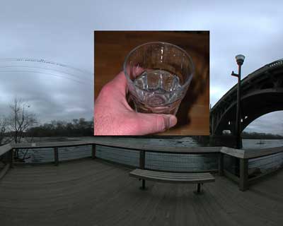
Please note that images will appear when you rollover a hotspot that has been "tagged." The first time you rollover there will be a delay while that image downloads. There are 255 hotspots that can be linked to images in each panorama. The images populate the panorama starting at hotspot 1, 2, 3 and so forth.
Click here to start "water means"
**To add images to "water means," email your camera phone images to donbgood.40478@uploads.photobucket.com. All images are stored on photobucket.com.
Comments or problems contact Don Barth at barthd@sc.edu.
Project Description
The project "water means" is a combination of mobile media, internet art, and installation art. The project includes three components/steps:
- Prior to an exhibition I will shoot a photographic panorama of the local river(s) or water sources in or near the exhibition city.
- The panoramic image(s) will be uploaded to this web site for display (here on the "water means" site). A call will go out inviting image "tagging" by the general public via the web. **See details above.
- During the exhibition, the installation component will be projected (12 by 9 feet), and a *"walking stick" interface (about 6 feet from the screen) will allow the audience to navigate the panorama.
The continuation of this work will be for me to travel to different locations in order to create a collection of localized responses to what water means to individuals in that local community. This collection then becomes a gestalt of each community’s relationship to its water. In addition, I can conduct workshops that include my techniques and processes. I want to educate and involve members of the communities so that they can then act as a catalyst for further exploration of these forms and cultural issues. This artwork is valuable for investigating how mobile media and the Internet can be used for collaborative artistic and cultural expression.
Both the form and content of this work deal with concepts and issues at the forefront of current global consciousness. This project is a continuation of my collaborative net art ("memory jar" and "location notation") and my interest in the natural environment ("a terrain's juncture" and "memory of leaves").
If you are interested in having me create and exhibit a version for your location, please contact me at barthd@sc.edu.
Project Notes
*The "walking stick" is a joystick (computer peripheral control device) modified to look like a wood stick, which is used to navigate the computer installation instead of a mouse. It has a button on the top end for mouse clicking.